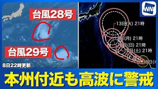
TOKYO - Two typhoons east of Japan were moving northward on August 30, with Typhoon No. 23 (Banlan) overtaking Typhoon No. 22 (Artau), although neither storm is expected to have a direct impact on Japan.
Satellite observations showed the two systems over waters far east of Japan as of 3 p.m. on August 30. Typhoon No. 23, which had initially been located south of No. 22, had moved ahead of it and was positioned to the northeast.
Sea surface temperatures are lower farther north of the storms, and both typhoons are expected to weaken as they move into the cooler waters.
As of 3 p.m. on August 30, Typhoon No. 22 had a central atmospheric pressure of 996 hectopascals and maximum sustained winds of 18 meters per second near its center, placing it only slightly above the threshold for classification as a typhoon.
No. 22 is forecast to initially move northeast before gradually turning north, following a path similar to No. 23. It is expected to weaken into a tropical depression by 3 p.m. on September 2.
Typhoon No. 23 was located northeast of No. 22 as of 3 p.m. on August 30, with a central atmospheric pressure of 992 hectopascals and maximum sustained winds of 25 meters per second near its center. It no longer had an area of storm-force winds.
No. 23 is expected to continue moving generally northward before becoming an extratropical cyclone south of the Aleutian Islands by 3 p.m. on September 1.
Neither Typhoon No. 22 nor Typhoon No. 23 is expected to directly affect Japan.
Source: ウェザーニュース