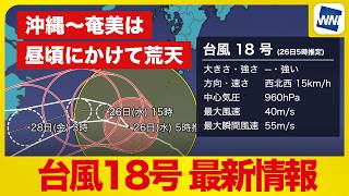
NAHA - Strong Typhoon No. 18 was gradually moving away from Okinawa and the Amami Islands on August 26 after disrupting flights and bringing violent winds, rough seas and heavy rain, although Okinawa's main island and Amami Oshima remained at risk of sudden downpours, powerful gusts and waves exceeding 6 meters through around midday. As of 4 a.m. on August 26, the typhoon was located about 80 kilometers west-northwest of Okinoerabu Island and was moving west-northwest at 15 kilometers per hour.
The storm had a central atmospheric pressure of 960 hectopascals, with maximum sustained winds of 40 meters per second near its center and maximum gusts of 55 meters per second, maintaining its strong intensity.
The typhoon was expected to continue moving slowly west-northwest while retaining its strength. Okinawa's main island and Amami Oshima were forecast to gradually move out of the strongest wind zone by around midday as the storm moved farther away.
Strong winds were still affecting the region during the morning, but conditions were expected to gradually improve during the afternoon and weaken further toward the evening.
Seas remained extremely rough, with wave heights exceeding 6 meters in some areas. Waves were forecast to gradually subside later in the day, although high waves and swells were expected to remain a danger even after the strongest winds eased.
Weather officials warned that bands of active rain clouds known as spiral bands were circulating around the typhoon's center and could cause rain and winds to suddenly strengthen as they passed over Okinawa and the Amami region.
Conditions could temporarily improve when an area entered a gap between the rainbands, but another spiral band could quickly bring renewed heavy rain and powerful winds. Residents were urged not to lower their guard even if conditions appeared to calm temporarily, with the danger expected to continue until around early afternoon.
The storm had already brought severe conditions to Okinawa on August 25.
On Minamidaito Island, powerful winds caused trees to sway violently, while a maximum instantaneous wind speed of 37.7 meters per second was recorded. An island resident described conditions at around 11 a.m. as the strongest experienced so far, saying the wind was roaring and that gusts hitting buildings produced impacts strong enough to make even concrete structures appear to shake.
As of 4 p.m. on August 25, Typhoon No. 18 had been about 160 kilometers east-southeast of Okinoerabu Island and moving west-northwest at 20 kilometers per hour, with maximum instantaneous winds forecast to reach 60 meters per second.
At Cape Kyan in Itoman, Okinawa Prefecture, rough seas pounded the rocky coastline ahead of the typhoon's closest approach, sending large sprays of water into the air.
The storm also disrupted air travel during the summer vacation season. Large numbers of passengers lined up at counters at Naha Airport to arrange alternative flights and make changes to their travel plans.
The Okinawa main island was expected to enter the typhoon's storm-force wind zone, while Kagoshima Prefecture was forecast to experience maximum gusts of 60 meters per second and as much as 250 millimeters of rain over a 24-hour period.
On Tokunoshima in Kagoshima Prefecture, supermarkets were already experiencing shortages of some products because of the typhoon's impact on deliveries.
The influence of the storm extended well beyond Okinawa and the Amami Islands as warm, humid air associated with the typhoon contributed to unstable atmospheric conditions elsewhere in Japan.
In Hokkaido, torrential rain caused flooding in parts of Sapporo on August 25. At around 9:30 a.m., vehicles sent waves of rainwater across inundated streets and onto sidewalks, while water poured from the guttering of buildings.
Rainfall was intense enough for spray bouncing from the asphalt to reduce visibility.
Warm and humid air flowing toward a low-pressure system and an autumn rain front made atmospheric conditions extremely unstable across Hokkaido. From around 7 a.m., a band of particularly intense rain capable of producing more than 50 millimeters per hour remained over parts of the region.
In Esashi, Hokkaido, heavy rain was driven almost horizontally by strong winds at around 10 a.m., sharply reducing visibility. Drivers switched on their headlights as they traveled through the storm.
Conditions also deteriorated in Hirosaki, Aomori Prefecture, from around noon, with large raindrops, thunder and strengthening winds.
At the same time, warm air associated with Typhoon No. 18 pushed temperatures higher across much of Japan.
Hita in Oita Prefecture recorded a maximum temperature of 38.9 degrees Celsius under strong sunshine, with intense heat rising from the asphalt and creating visible heat haze.
Kumamoto City also experienced dangerous heat, with the temperature climbing to 38.4 degrees shortly before 2 p.m.
For Okinawa and the Amami Islands, the peak of the typhoon's impact was expected to gradually pass during the afternoon of August 26, but residents were being urged to continue monitoring the latest weather information and remain in safe locations while the risk of strong winds, sudden heavy rain, high waves and swells persisted.
Source: ウェザーニュース