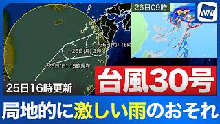
TOKYO - Three typhoons are now active in waters around Japan, raising concerns that the unusual cluster could affect the upcoming three-day weekend as Typhoon No. 27 approaches the Ogasawara Islands and two additional storms develop farther east. Satellite images from the Himawari weather satellite showed three distinct tropical systems around Japan on October 5.
Typhoon No. 27 had a clearly defined eye and a broad cloud system, while Typhoon No. 28 was more compact but also had a distinct center. Typhoon No. 29 remained less organized.
Typhoon No. 27 was classified as a large and very strong storm near the Ogasawara Islands, with a central atmospheric pressure of 935 hectopascals, maximum sustained winds of 45 meters per second and maximum gusts of 65 meters per second. It was moving at about 20 kilometers per hour.
The storm was expected to gradually turn eastward and move into waters east of Japan by 9 p.m. on October 6 before becoming an extratropical cyclone by 9 p.m. on October 7.
Strong winds were already affecting the Ogasawara Islands, and conditions were expected to remain windy through at least the evening of October 6 even as the typhoon moved away. High waves were also forecast, with rough seas expected to spread toward the Pacific coasts of the Kanto and Tohoku regions.
Typhoon No. 28 formed after Hurricane Nolo crossed the International Date Line from the eastern Pacific, becoming the first so-called crossover typhoon in three years. The system had previously been monitored by the U.S. National Hurricane Center before entering the area overseen by the Japan Meteorological Agency.
As of 9 p.m. on October 5, Typhoon No. 28 was a very strong storm near Midway Atoll, moving westward at about 25 kilometers per hour. Its central pressure was 955 hectopascals, with maximum sustained winds of 50 meters per second and gusts reaching 70 meters per second.
The typhoon was forecast to approach the vicinity of Minamitorishima by 9 p.m. on October 9 before gradually changing course toward the east. Forecasters cautioned that considerable uncertainty remained over its future track.
Typhoon No. 29 was near the Marshall Islands at 9 p.m. on October 5 and was moving northwest at about 15 kilometers per hour. It was expected to strengthen as it moved northward and become a strong typhoon near Minamitorishima by 9 p.m. on October 10, with a central pressure of 965 hectopascals, maximum sustained winds of 40 meters per second and gusts of 55 meters per second.
Forecast models from several countries showed a wide range of possible tracks for Typhoon No. 29, adding further uncertainty over how the three tropical systems could affect Japan during the coming days.
The development of Typhoons No. 28 and No. 29 on October 5 created a rare triple-typhoon situation around the Japanese archipelago. Typhoon No. 27 was expected to approach Tokyo's Ogasawara Islands during the night of October 5, while the broader weather pattern raised concerns about possible disruption during the upcoming three-day weekend.
The unsettled conditions came just after a prolonged spell of rain in Tokyo had ended. No rain fell in the capital on October 3, bringing the record-setting wet period to a close, but rain returned on October 5.
Strong winds accompanied fine, mist-like rain in Tokyo, pushing temperatures sharply lower. At 11 a.m., the temperature was just 18.2 degrees Celsius, making conditions unusually chilly.
The change followed a weekend of largely favorable sightseeing weather across the country. In Daisen, Akita Prefecture, about 8,000 fireworks created by local pyrotechnicians lit up the autumn night sky during a fireworks arts festival, drawing large crowds.
Autumn food events also attracted visitors. In Odawara, Kanagawa Prefecture, long lines formed for the annual Yamayasu Sanma Festival, organized by a long-established dried-fish company.
Pacific saury were grilled over charcoal and served to visitors who made donations of at least 100 yen. The company had reserved larger, fattier fish especially for the event so visitors could enjoy high-quality seasonal saury.
Charcoal-grilled saury was also accompanied by saury takikomi gohan, a seasoned rice dish sold for 500 yen.
Weather conditions changed sharply as the new week began on October 5, with rain also falling in parts of Chiba Prefecture that were still recovering from record rainfall and a series of landslides caused by an earlier typhoon.
In Shisui, where flooding has persisted, water levels had fallen significantly compared with conditions observed on October 2. Tires on partially submerged vehicles had become visible as the water receded.
Yuta Hoshina of the Kaiun housing complex said the water had fallen considerably over the previous two days and was now about 40 centimeters deep.
However, the falling water level has created a new problem. Stagnant rainwater has begun to produce algae and an increasingly strong odor.
Hoshina said that because the accumulated water was not circulating, it had started to deteriorate, creating algae and a smell strong enough to irritate the nose.
At a drainage channel affected by sediment, workers were inspecting the area around an underground drainage pipe buried by a landslide.
Residents had repeatedly asked authorities to lower the water level and begin work on the damaged drainage system, Hoshina said, expressing frustration that significant work was only now getting underway about two weeks after the flooding began.
There is still no clear indication of when the remaining water will fully drain. Hoshina said 10 households, representing more than 20 people, remained evacuated.
Elsewhere, residents in Shikoku were urged to remain alert for localized downpours and thunderstorms.
Rain also spread across the Kanto region, with strong winds accompanying showers in Yokohama, Kanagawa Prefecture.
Temperatures remained low in central Tokyo, where the mercury did not rise above 20 degrees Celsius until around 1 p.m. on October 5.
Conditions were forecast to reverse sharply on October 6, when Tokyo was expected to reach 29 degrees Celsius, close to the threshold for a midsummer day.
The large day-to-day temperature swings, combined with continuing rain, wind and uncertainty surrounding the three typhoons, were expected to require particular attention to health and changing weather conditions.
Latest: Typhoons 28 and 29 Forecast to Turn North Around Weekend
Source: ウェザーニュース