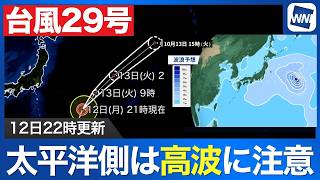
TOKYO - Typhoon No. 15 continued moving west across central Japan on August 12, but heavy rain, strong winds and thunderstorms remained a threat far from the storm's center, with intense rainfall reported in parts of Tokyo and damage including fallen and broken trees in Ibaraki and Tochigi prefectures.
As of 5 a.m. on August 12, the typhoon was near Ogaki, Gifu Prefecture, moving west at about 40 kilometers per hour. Its central pressure was 996 hectopascals, with maximum sustained winds of 18 meters per second and maximum gusts of 25 meters per second.
The storm was no longer accompanied by a storm-force wind zone and was not expected to strengthen. It was forecast to continue westward and weaken into a tropical depression over waters off the Sanin region by early August 13.
Despite the typhoon moving away from Kanto after passing through the region, strong rain continued in areas well removed from its center. Intense rainfall was observed in parts of the Tokyo metropolitan area, including Nakano Ward, while thunderstorms were also affecting parts of Kanto.
Strong rain was also reported in eastern Sanin, northern Kinki and along the Sanriku coast of northeastern Japan.
Forecasters warned that the typhoon's unusual weather pattern was producing strong winds and rain far from its center. Winds exceeding 10 meters per second were being observed in parts of Niigata Prefecture and even along the Pacific side of Hokkaido, while winds near the typhoon's center were comparatively weak.
Through the daytime on August 12, heavy rain accompanied by thunder was expected across a broad area including Kanto, the Sanriku coast of Tohoku and the Chugoku region.
Kanto residents were warned not to assume the danger had passed simply because the typhoon was moving farther away. Rainfall could become heavier on August 12 than it had been while the storm was passing through the region.
Particular caution was urged along the Sanriku coast, where local topography could cause rainfall totals to increase sharply and raise the risk of landslides.
Damage from the typhoon was also becoming clearer as daylight returned, with reports of fallen trees and broken roadside trees in Ibaraki and Tochigi prefectures.
Authorities urged people heading outdoors to remain alert to their surroundings and to continue monitoring the latest weather information as the threat of heavy rain, thunderstorms and strong winds persisted even after the typhoon's departure.
Source: ウェザーニュース