

Japan is bracing for violent winds, blizzards and heavy snowfall from November 19 as a rapidly intensifying low-pressure system brings winter storm conditions to the Sea of Japan coast, with northern regions facing the greatest risk through the three-day holiday weekend and snow potentially reaching mountainous areas of the Kanto region.
Strong winds have already developed along the Sea of Japan coast from northern to eastern Japan, with Kanazawa in Ishikawa Prefecture recording a maximum instantaneous wind speed of 27.3 meters per second. Gusts of up to 35 meters per second, equivalent to the force of a typhoon, are forecast for Hokkaido and the Hokuriku region on November 19.
The winter pressure pattern is expected to strengthen through November 20 as a mass of intensely cold air moves over Japan, bringing a sharp drop in temperatures and causing rain along the Sea of Japan coast to turn into snow. Snowfall is forecast to intensify from the evening of November 19, with parts of northern Japan potentially experiencing heavy snow and blizzards severe enough to trigger weather warnings.
As of 11:50 a.m. on November 19, gale warnings had been issued for Ishikari City and Okushiri Town in Hokkaido, where extremely strong westerly winds are expected to continue through midday on November 20.
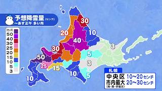
Hokkaido faces particularly heavy snowfall, with up to 50 centimeters forecast over the 24 hours ending at midday on November 20 in western Shiribeshi and areas around the foot of Mount Yotei. The Kamikawa and Sorachi regions could receive up to 40 centimeters.
In Sapporo, snowfall is expected to reach 10 to 20 centimeters in Chuo Ward and as much as 30 centimeters in mountainous districts. Residents are being advised to check conditions around their homes early on November 20, when snow accumulation could disrupt morning travel.
Snow and blizzard conditions are expected to continue across central and southern Hokkaido on November 20, potentially disrupting trains, buses and other transportation services. Sapporo's daytime high is forecast to reach just 1 degree Celsius, bringing temperatures comparable to those normally experienced at the end of December.
In northern Hokkaido, heavy snowfall is expected particularly in inland areas of Kamikawa and Soya, with further accumulation possible through November 22. Eastern Hokkaido, however, is expected to enjoy relatively clear weather during the holiday period.
Meteorologists are also monitoring the Japan Sea Polar Air Mass Convergence Zone, known as JPCZ, a weather phenomenon that can produce concentrated bands of heavy snowfall when cold northwesterly winds converge over the Sea of Japan. Its influence could extend snowfall into mountainous areas of the Kanto region over the weekend.
The combination of strong winds, accumulating snow and falling temperatures raises the risk of icy roads, skidding accidents, reduced visibility and snow adhering to trees and infrastructure. Drivers traveling through mountainous areas or across northern Japan during the holiday period are being urged to exercise particular caution.
The strongest winds are expected between November 19 and November 20, with conditions generally easing by November 21. Although transportation disruptions remain possible, widespread severe wind-related disruption is not currently expected to continue into Saturday.
Despite the severe conditions in northern Japan, much of the Pacific coast is expected to enjoy relatively favorable weather during the three-day weekend from November 21 to November 23, which includes the Labor Thanksgiving Day holiday on Monday.
Tokyo, Nagoya and other major cities along the Pacific coast are forecast to experience generally sunny and stable conditions through November 23, making the holiday period suitable for outdoor activities and travel.
Western Japan will see more varied conditions during the first half of the holiday period. Fukuoka is likely to experience occasional rain as the winter pressure pattern affects the region, while Hiroshima, the Sanin region and northern Kinki could also see showers.
High pressure is expected to move in from the west on November 22, gradually weakening the winter weather pattern and bringing improving conditions to many areas. Sunshine is forecast across much of western Japan, including Okinawa, during the latter half of the holiday weekend.
Northern Japan and the Hokuriku region, however, are expected to experience more frequent cloudy, rainy or snowy days, reflecting the increasing influence of winter weather systems.
Sapporo could receive additional snow on November 20 and November 21, although snowfall during the latter part of the weekend may not be sufficient to produce significant new accumulation in some urban areas. Central and southern Hokkaido could see periods of sunshine on November 22.
Weather conditions are expected to deteriorate again from November 23 as a low-pressure system and associated front approach Japan. Rain could begin in parts of Kyushu on the final day of the holiday, before spreading across much of the country on November 24.
Another strong winter pressure pattern is forecast to develop around November 25, potentially bringing renewed cold weather, rain and snow to northern Japan and areas along the Sea of Japan coast. The outlook through November 26 suggests increasingly frequent periods of wintry weather as the country moves toward December.
Meteorologists are advising travelers to monitor forecasts not only for their home regions but also for their destinations, particularly when traveling to Hokkaido, Hokuriku and mountainous areas where conditions can change rapidly.
With heavy snow, strong winds and icy roads posing the greatest dangers during the early part of the holiday period, travelers are being urged to allow extra time for journeys and check the latest weather and transportation information before departure.
Source: FNN