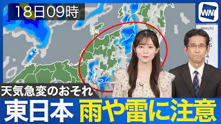
TOKYO - Japan's Meteorological Agency announced on June 7th that the rainy season is believed to have begun in the Tokai and Kanto-Koshin regions, marking the seasonal shift to wetter weather across a broad area of the country.
Atmospheric conditions have become highly unstable, particularly in western Japan, due to the influence of a seasonal rain front and a low-pressure system. Heavy rainfall is expected to continue through noon on June 8th, with rainfall totals forecast to reach up to 200 millimeters in Shikoku.
Authorities are urging residents to remain vigilant for landslides, rising river levels, flooding in low-lying areas, and other weather-related hazards associated with the prolonged rain.
According to the agency, the start of the rainy season in the Tokai region came one day later than the annual average, while the Kanto-Koshin region entered the season at roughly the usual time.
Compared with last year, when the rainy season arrived significantly earlier than normal, this year's onset was 21 days later in Tokai and 16 days later in Kanto-Koshin.
Rain is expected to affect parts of eastern Japan early next week, particularly on June 9th, although forecasters say there could be periods of sunshine afterward as the rainy season temporarily eases. However, localized downpours remain possible in inland and mountainous areas.
Meteorologists also warn that the Pacific high-pressure system south of Japan is expected to strengthen during June, increasing the likelihood that the seasonal rain front will remain stalled near Honshu. As a result, eastern Japan's Pacific coast could face periods of heavy rain, especially during the second half of June, raising the risk of flooding and other weather-related impacts.
Source: FNN