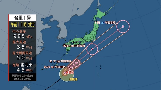
TOKYO, May 29 (News On Japan) - Typhoon No. 1 is expected to approach the Daito Islands in Okinawa by Wednesday evening. Residents in the Daito Islands should remain cautious of strong winds and high waves. The region could experience winds exceeding 25 meters per second, resulting in stormy conditions. The sea will also be very rough with large swells.

As the typhoon continues to move north, it is expected to pass south of the Kanto region on Friday. The moist air surrounding the typhoon combined with the cold air in the upper atmosphere will likely cause rain clouds to develop near Kanto. This means heavy rain is expected in Kanto on Friday. Coastal areas will also experience strong winds and temporarily stormy weather.
Wednesday's Forecast
Despite the early morning storm, Kanto will see clear skies on Wednesday afternoon, May 29. Tohoku is also expected to clear up. Western Japan will continue to enjoy typical May weather. Temperatures will be higher than Tuesday, with Tokyo expected to reach a high of 28 degrees, making it a hot day.
Thursday's Forecast
High pressure will cover most areas on Thursday, May 30, leading to sunny conditions during the day. However, moist air from the typhoon will move in by evening, causing rain in the Pacific regions from Kanto to Kyushu. Those returning home in the evening should carry rain gear.
Source: TBS


