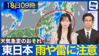
TOKYO - The Kanto region is experiencing an unusual June, with three typhoons approaching the area during the month and rainfall totals already reaching record levels in some locations.
A review of rainfall across Kanto through yesterday showed that some areas had received more than 300 millimeters or 400 millimeters of rain this month. Choshi recorded 513 millimeters, the highest June total in its observation history. The amount was more than double or even triple the normal level in many areas, underscoring how unusually wet the month has been.
Far to the south of Japan, clouds are continuing to form one after another over the ocean and are beginning to organize. A forecast weather map for 9 a.m. tomorrow shows two tropical depressions, potential precursors to typhoons, developing in the area. Continued caution is needed over possible typhoon activity.
The latest one-month forecast released on Thursday predicts that average temperatures in the Kanto region will be higher than normal.
In Tokyo, the forecast for the next 16 days indicates that cloudy and rainy weather typical of the rainy season is likely to continue for about a week. After that, more days with sunny intervals are expected.
The rainy season in the Kanto-Koshin region normally ends around July 19, but this year it may end earlier than usual. Heat is also expected to intensify gradually.
Daily highs in Tokyo are forecast to remain around 30 degrees Celsius, with temperatures from Saturday, July 11, likely to rise to 33 or 34 degrees, approaching the threshold for extremely hot days. Residents are urged to take greater precautions against heatstroke.
Source: TBS