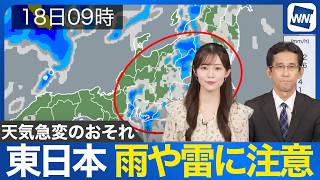
TOKYO - A low-pressure system in the Pacific is expected to strengthen into a typhoon, with forecasts raising the possibility of it sweeping across Japan later this week. Meanwhile, unstable atmospheric conditions on September 3rd triggered sudden downpours and thunderstorms across the Kanto region, leading to flooding and property damage in several areas.
In Tochigi Prefecture, violent claps of thunder were followed by a sudden deluge of rain. In Kamimikawa Town, heavy rainfall obscured visibility as large raindrops pelted down. One resident reported, "The waterway is close to overflowing and can no longer hold the rain."
Rainwater pooled in parking lots and spilled onto the roads, threatening to breach nearby waterways. In Moka City, streets were submerged, resembling rivers as cars crawled forward, spraying water in all directions. Some vehicles were forced to turn back due to the inundation.
The Japan Meteorological Agency issued "record-breaking short-term heavy rain" alerts for parts of Tochigi and Ibaraki prefectures. Around 110 millimeters of rain fell near Oyama City within one hour before 6 p.m., while approximately 120 millimeters was recorded near Yūki City.
The sudden downpours also brought hail to certain areas. In Moka City, strong winds toppled greenhouses, bending metal frames and scattering vinyl sheeting, some of which became entangled in a nearby steel tower.
Wind damage was also reported in urban areas. In front of Oyama Station, a tree split down the middle, forcing cars to maneuver around it. Flowerpots nearby were knocked over, and city workers rushed to remove fallen branches.
In the Hokuriku and Tohoku regions, intense thunderstorms struck from the early hours. In Niigata Prefecture, widespread flooding was reported, with the Joetsu City Driver's License Center forced to close due to water damage.
“It happened so quickly in the morning. The floor was already flooded before we realized it,” said a visitor who had come for business.
Akita Prefecture also experienced record-setting rainfall, with several rivers overflowing since September 2nd. In Kitaakita City, 236.5 millimeters of rain fell in 24 hours, the highest level ever recorded in the area.
Meanwhile, a tropical depression south of Japan is forecast to develop into a typhoon. It is expected to approach Kyushu on September 4th and may later move across Honshu. Authorities are closely monitoring its trajectory and potential impact.
Source: TBS