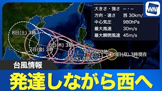
TOKYO, Nov 05 (News On Japan) - As of 3 p.m. on November 5th, a tropical depression over the sea near the Caroline Islands was slowly moving northward, with the Japan Meteorological Agency forecasting that it would develop into a typhoon within the next 24 hours. Once it forms, it will be designated as Typhoon No. 26.
The agency reported that the system’s central pressure was around 1,100 hectopascals, with maximum sustained winds of 15 meters per second and gusts reaching up to 23 meters per second. Satellite images show the cloud formations gradually becoming more organized, suggesting further development.
By November 6th, the depression is expected to intensify into a full typhoon with a central pressure of about 998 hectopascals, maximum winds of 18 meters per second, and gusts of 25 meters per second. Forecast models indicate that the system will continue to strengthen as it moves northwestward, passing near 30 degrees north latitude.
The storm is projected to grow into a strong typhoon east of the Philippines around November 9th and could approach the Philippine region by November 10th. Depending on its future course, Japan may also be affected. The Meteorological Agency has urged residents in potentially impacted areas to stay alert and follow the latest weather updates as the system develops.
Source: ウェザーニュース


